Farm Survey and Planning: Tools, Techniques, and Importance in Agriculture
Farm survey and planning are foundational steps in establishing a productive and sustainable agricultural venture. Before planting begins or structures are erected, a detailed understanding of the land—its topography, resources, and potential—is critical. This is where farm surveying and planning come into play.
In this blog post, we’ll explore what farm survey and planning entail, the materials required, and how each component contributes to the overall success of a farm project.
What Is Farm Surveying?
Farm surveying is the process of measuring and mapping out a piece of land to determine its features, boundaries, and usability for agricultural purposes. It involves technical measurements to assess:
Land shape and size
Slope or gradient
Water availability
Existing vegetation and infrastructure
These data points are then used to make informed decisions about farm layout, irrigation, road construction, building placements, and more.
Importance of Farm Survey and Planning
- Efficient Land Use – Ensures that each portion of land is used optimally, increasing productivity.
- Prevent Soil Erosion – Helps identify slopes and plan accordingly.
- Water Management – Assists in designing proper drainage and irrigation.
- Infrastructure Placement – Aids in positioning farm buildings, roads, and fences.
- Cost Reduction – Minimizes waste and guides resource allocation.
- Legal Boundary Clarification – Determines exact land limits to avoid disputes. check out this post on land tenure system
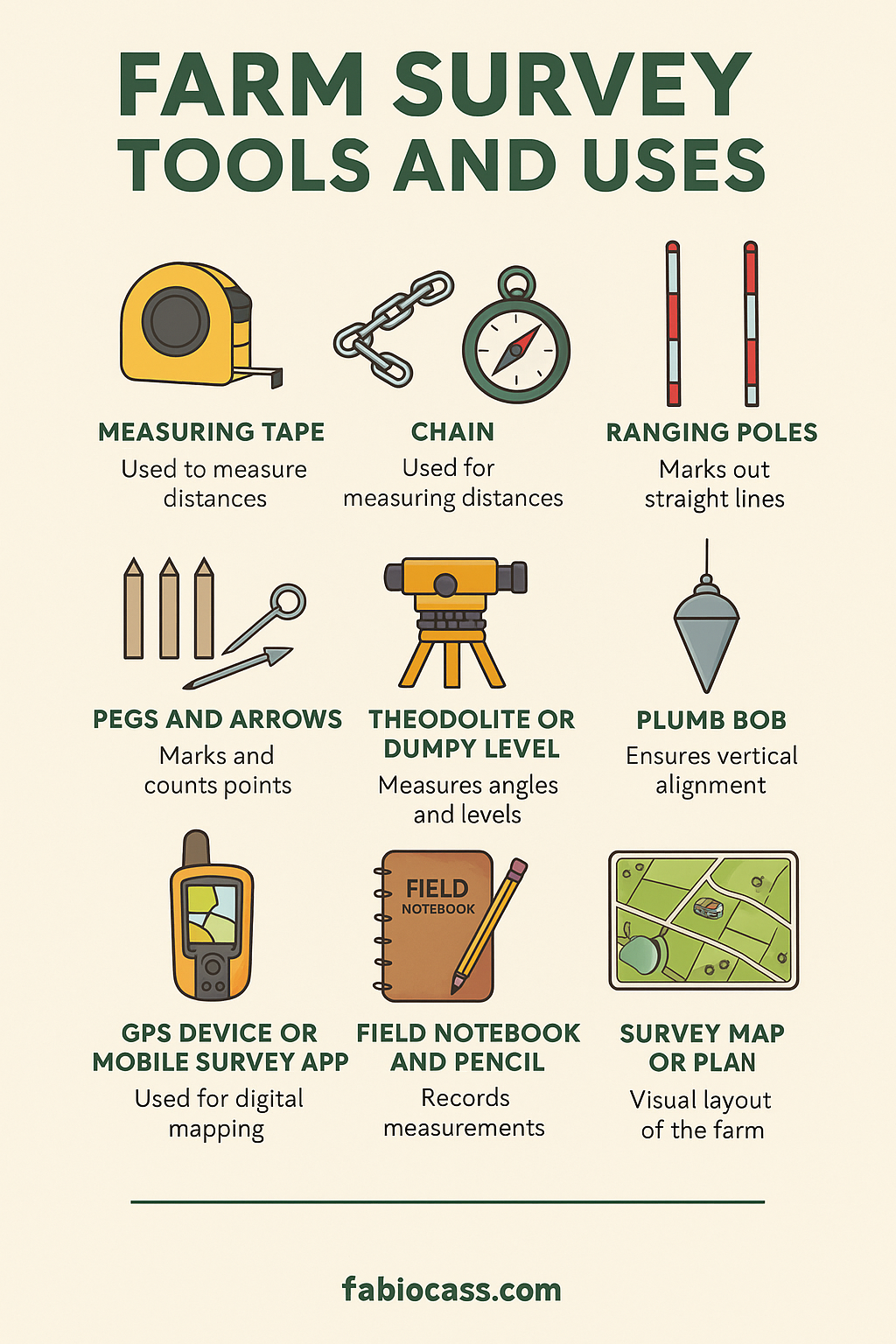
Materials Used in Farm Survey and Their Explanations
Below are the essential tools and materials used in farm surveying, along with their functions and images
- Measuring Tape
Function: Used to measure short distances between points on the land.
Material: Usually made of flexible steel or fiberglass.
Use: Ideal for measuring distances between boundary pegs or internal plot divisions.

- Chain (Surveyor’s Chain)
Function: Used for measuring longer distances on the field.
Material: Made of galvanized steel links.
Use: Common in boundary mapping and field dimension surveys.

- Compass
Function: Determines direction and orientation of the land.
Use: Helps identify North, South, East, and West directions for aligning farm rows and structures.

- Ranging Poles
Function: Used to mark out straight lines over long distances.
Material: Colored metal or wooden poles for visibility.
Use: Helpful when laying out roads, fences, and boundaries.

- Pegs and Arrows
Function: Pegs are used to mark points; arrows are used to count chain lengths.
Use: Pegs mark corners, paths, or specific features on the land.

- Theodolite or Dumpy Level
Function: Measures angles (horizontal and vertical) and levels.
Use: Advanced tool for contour mapping, irrigation layout, and construction work.

- Field Notebook and Pencil
Function: Records measurements, sketches, and observations.
Use: Every good surveyor must document findings for planning and reference.
Image Suggestion:
- Plumb Bob
Function: Ensures vertical alignment.
Use: Often used in conjunction with other instruments to align posts or check elevation differences.
Image Suggestion:
- GPS Device or Mobile Survey App
Function: Used for digital mapping and geo-coordinates.
Use: Modern farms use GPS-enabled tools to map land digitally.
Image Suggestion:
- Survey Map or Plan
Function: A visual layout of the surveyed farm.
Use: The final product of a farm survey used in planning and development.
Image Suggestion:
Steps Involved in Farm Planning
- Reconnaissance Survey – Preliminary observation to understand the site.
- Detailed Measurement – Use tools like chains and compasses.
- Topographical Assessment – Identify slopes, elevations, and lowlands.
- Soil Testing and Water Availability Check
- Farm Layout Design – Allocate areas for crops, livestock, buildings, and roads.
- Implementation of Infrastructure – Start construction and installations.
Conclusion
Effective farm survey and planning ensure a farm is productive, sustainable, and economically viable. By using the right tools and following methodical planning steps, farmers can avoid costly mistakes and maximize land potential. Whether it’s a small garden or a commercial plantation, every successful farm begins with careful measurement and thoughtful planning.
Originally posted 2025-07-23 15:27:55.